Sponsored
Hootbro
Well-Known Member
Not 100% sure but I think the altitude measurement is based off the LAT/LONG GPS signal mapping and not a true baro altimeter measurement. Is the GPS present position LAT/LONG also reporting?
ShadowsPapa
Well-Known Member
- First Name
- Bill
- Joined
- Oct 12, 2019
- Threads
- 247
- Messages
- 40,442
- Reaction score
- 53,860
- Location
- Runnells, Iowa
- Vehicle(s)
- '25 JTMX, '23 JLU 4xe, '82 SX4, '73 Javelin
- Occupation
- Retired auto mechanic, frmr gov't ntwrk security admin
- Vehicle Showcase
- 3
Mine is very detailed - or it seems. One of our longest grade changes not far from me shows me at something like 929 feet at the top of the hill and 819 feet at the bottom before it starts going back up again, and I can watch it keep up pretty well as I go up or down the hill.
I don't know HOW it gets the info - but it's to the foot and increments very nicely as I drive.
I doubt our areas are mapped that well, so I'd guess it's figuring distances from the satellites or a true altimeter sort of situation but to get it to the foot from a satellite is pretty good - GPS locations aren't typically that accurate or fast. (well, not with my Garmin anyway)
Hootbro
Well-Known Member
Google foo says you need three satellite for position and a fourth satellite for a determination of altitude.Nope not getting any of it.
I assume you are using the 8.4 radio with NAV? If so, does the actual GPS navigation work (not Android Auto or Apple Car Play) and plot a route and track as you move? If it does, then I would lean on the a radio software issue rather than a antenna reception issue.
Last edited:
Sponsored
ShadowsPapa
Well-Known Member
- First Name
- Bill
- Joined
- Oct 12, 2019
- Threads
- 247
- Messages
- 40,442
- Reaction score
- 53,860
- Location
- Runnells, Iowa
- Vehicle(s)
- '25 JTMX, '23 JLU 4xe, '82 SX4, '73 Javelin
- Occupation
- Retired auto mechanic, frmr gov't ntwrk security admin
- Vehicle Showcase
- 3
That makes perfect sense as you have to triangulate for position (and speed) and the 4th for altitude, yeah, I could see that. Whatever the case, mine was accurate as heck. I checked twice - going up and down that hill, and the numbers were pretty close to each other both times.Google foo says you need three satellite for position and a fourth satellite for a determination of altitude.
I assume you are using the 8.4 radio with NAV? If so, does the actual GPS navigation work (not Android Auto or Apply Car play) and plot a route and track as you move? If it does, then I would lean on the a radio software issue rather than a antenna reception issue.
OP
OP
Koja
Well-Known Member
- Thread starter
- #7
Sitting in a parking lot, clear field of view no mt's and it does not pick up. but the Nav GPS works just fine.Google foo says you need three satellite for position and a fourth satellite for a determination of altitude.
I assume you are using the 8.4 radio with NAV? If so, does the actual GPS navigation work (not Android Auto or Apple Car Play) and plot a route and track as you move? If it does, then I would lean on the a radio software issue rather than a antenna reception issue.
TLife
Well-Known Member
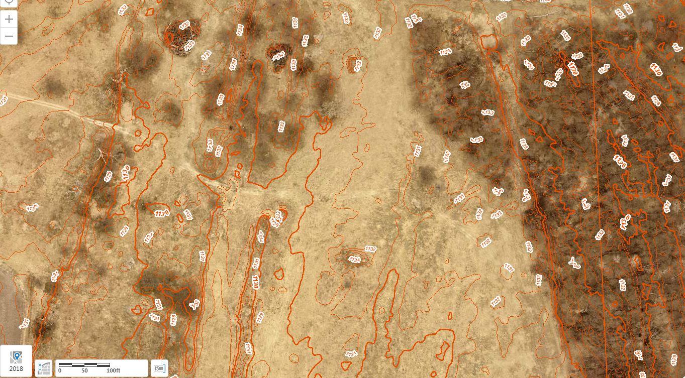
I think you'd be surprised how accurate the topos are that are available. More and more counties are putting that information online via a Geographic Information System (GIS). Here's a random bit of field and trees from the Douglas County GIS with 1' elevation lines. Not saying that's how the Gladiator gets it's elevation data, but that information is available.I doubt our areas are mapped that well
ShadowsPapa
Well-Known Member
- First Name
- Bill
- Joined
- Oct 12, 2019
- Threads
- 247
- Messages
- 40,442
- Reaction score
- 53,860
- Location
- Runnells, Iowa
- Vehicle(s)
- '25 JTMX, '23 JLU 4xe, '82 SX4, '73 Javelin
- Occupation
- Retired auto mechanic, frmr gov't ntwrk security admin
- Vehicle Showcase
- 3
Yes - Those red lines- VERY close together for my area ;-)I think you'd be surprised how accurate the topos are that are available. More and more counties are putting that information online via a Geographic Information System (GIS). Here's a random bit of field and trees from the Douglas County GIS with 1' elevation lines. Not saying that's how the Gladiator gets it's elevation data, but that information is available.

Digging into current info, they do have things mapped out pretty well, but where I live, the Jeep was showing elevation changes extremely fast and accurate. So not sure what they are using, my bet - GPS as it's been extremely accurate in this Jeep.
OP
OP
Koja
Well-Known Member
- Thread starter
- #10
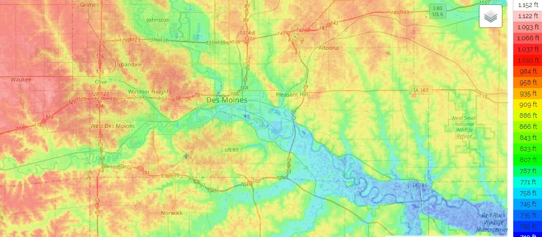
But Iowa is flat. I know I was stuck in Newton for two monthsYes - Those red lines- VERY close together for my area ;-)
Digging into current info, they do have things mapped out pretty well, but where I live, the Jeep was showing elevation changes extremely fast and accurate. So not sure what they are using, my bet - GPS as it's been extremely accurate in this Jeep.


Sponsored
ShadowsPapa
Well-Known Member
- First Name
- Bill
- Joined
- Oct 12, 2019
- Threads
- 247
- Messages
- 40,442
- Reaction score
- 53,860
- Location
- Runnells, Iowa
- Vehicle(s)
- '25 JTMX, '23 JLU 4xe, '82 SX4, '73 Javelin
- Occupation
- Retired auto mechanic, frmr gov't ntwrk security admin
- Vehicle Showcase
- 3
I hope you at least got to sample the Maytag cheese.......................But Iowa is flat. I know I was stuck in Newton for two months
Newton - you run NASCAR, do you?
It's fairly flat all around Newton compared to my area. I have some hills to get there, it's worse a bit east of Newton.
Did you get to explore the area? Since Maytag pulled out, I don't think there's much there worth going for other than the track.
Hootbro
Well-Known Member
Yeah, that is probably going to be software related. I would either see about a trying to find a soft radio reset procedure and/or look for a system update to see if that clears it up. All else fails, warranty claim time and let the dealer figure it out.Sitting in a parking lot, clear field of view no mt's and it does not pick up. but the Nav GPS works just fine.
https://www.driveuconnect.com/support/software-update.html
Sponsored